

The Indus Valley Civilisation, also known to archaeologists as the Harappan Civilisation, was the Bronze Age urban society that flourished across the alluvial plains of the Indus and Ghaggar-Hakra river systems in modern Pakistan and north-western India between roughly 3300 BC and 1300 BC, reaching its mature urban peak from 2600 BC to 1900 BC. Spanning more than one million square kilometres, it built the ancient world’s largest geographical network of planned brick cities, municipal sanitation systems, and standardised trade weights. Beyond its famous baked-brick drains and carved steatite seals, the absence of royal palaces, the statistical puzzle of its undeciphered script, and the 2019 Rakhigarhi ancient-DNA genome have transformed how historians understand South Asia’s earliest cities.
Key facts
- Dates: Early Harappan phase c. 3300–2600 BC; Mature Harappan urban phase c. 2600–1900 BC; Late Harappan de-urbanisation c. 1900–1300 BC
- Major urban centres: Harappa (Punjab, Pakistan), Mohenjo-daro (Sindh, Pakistan), Rakhigarhi (Haryana, India), Dholavira and Lothal (Gujarat, India), Ganeriwala (Cholistan, Pakistan), Kalibangan (Rajasthan, India)
- Key rulers or commanders: None identified by name; no royal palaces, dynastic king-lists, or monumental royal tombs have ever been excavated
- Peak size and population: Approximately 1 million to 1.25 million square kilometres across more than 1,500 documented settlements; estimated peak population of 1 million to 5 million inhabitants (with Mohenjo-daro and Harappa housing 30,000 to 60,000 residents each)
- Outcome: Gradual de-urbanisation after 1900 BC driven by weakening summer monsoons, shifting river courses, and the disruption of Persian Gulf maritime trade, followed by eastward rural migration into the Indo-Gangetic plain
Origins and discovery of the Indus Valley Civilisation
The Indus Valley Civilisation developed indigenously out of Neolithic farming and pastoral communities in the hills of Balochistan and the Indus basin, yet its existence was completely forgotten until archaeologists excavated Harappa and Mohenjo-daro in the 1920s. At its Mature Harappan height between 2600 BC and 1900 BC, it covered an area larger than contemporary Old Kingdom Egypt and Bronze Age Mesopotamia combined.
How 1920s excavations revealed a forgotten Bronze Age world
Throughout the nineteenth century, British colonial engineers and antiquariansassumed that urban life in the Indian subcontinent began only in the first millennium BC along the Ganges River. When the British deserter and traveller Charles Masson visited the brick mounds of Harappa in Punjab in 1829, and when Alexander Cunningham — later the first Director-General of the Archaeological Survey of India (ASI) — published an enigmatic square stone seal bearing a one-horned bull and six unknown characters from Harappa in 1875, neither realised the site belonged to the Bronze Age. Mid-nineteenth-century railway contractors even quarried millions of ancient kiln-fired bricks from the Harappa mounds to lay track ballast along the Lahore–Multan railway line.
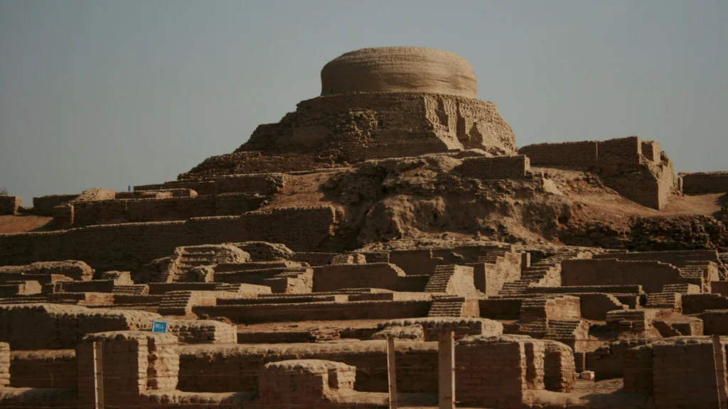
The chronological breakthrough came between 1920 and 1924 under ASI Director-General Sir John Marshall. In 1921, Indian archaeologist Daya Ram Sahni began systematic trenching at Harappa, while in 1922 Rakhal Das Banerji excavated beneath a Buddhist stupa mound at Mohenjo-daro in Larkana District, Sindh, uncovering superimposed layers of fired-brick buildings and engraved steatite seals. When Marshall published those discoveries in the Illustrated London News on 20 September 1924, the scholarly world learned of a hitherto unknown urban society. Within days, Assyriologists Ernest Mackay and C. J. Gadd matched the newly published Indian seals with identical Indus-style seals excavated from stratified third-millennium BC Mesopotamian levels at Kish and Susa, proving overnight that the cities along the Indus were contemporaries of Sargon of Akkad and the pyramid builders of Ancient Egypt.
Geographic extent and developmental chronology
Subsequent excavations across Pakistan, India, and northern Afghanistan revealed that Harappa and Mohenjo-daro were only two metropolitan hubs within a vast ecological network. Stretching from Shortugai on the Oxus (Amu Darya) River in northern Afghanistan — founded to control Badakhshan lapis lazuli mines — south to Daimabad in Maharashtra, and from Sutkagen Dor on the Makran coast near the Iranian border east to Alamgirpur near Delhi, Harappan settlements spanned roughly 1 million to 1.25 million square kilometres.
In his authoritative synthesis The Ancient Indus Valley: New Perspectives (2008), Jane McIntosh notes that archaeologists led by Jonathan Mark Kenoyer and Jim G. Shaffer divide this long trajectory into four developmental eras rather than treating the cities as a sudden foreign import. The Early Food-Producing Era (c. 7000–5500 BC), documented by Jean-François Jarrige’s French excavations at Mehrgarh on the Kacchi Plain of Balochistan, saw the local domestication of zebu cattle (Bos indicus), the cultivation of six-row barley and einkorn wheat, and early copper bead-working and dental drilling. During the Regionalisation Era or Early Harappan phase (c. 3300–2600 BC, corresponding to the Ravi and Kot Diji phases at Harappa), walled agricultural towns developed grid-planned streets, wheel-thrown painted pottery, and early potter’s marks across the Indus and Ghaggar-Hakra valleys.
Around 2600 BC, a rapid transition — often accompanied by site rebuilding at settlements such as Kalibangan and Kot Diji — inaugurated the Integration Era or Mature Harappan phase (c. 2600–1900 BC). Across more than 1,500 documented villages, coastal ports, and five major urban centres exceeding 80 to 300 hectares in area (Mohenjo-daro, Harappa, Ganeriwala, Rakhigarhi, and Dholavira), communities adopted identical 1:2:4 brick proportions, cubical chert weights, and square steatite seals, before transitioning into the Localisation Era (Late Harappan phase, c. 1900–1300 BC).
Mohenjo-daro, urban planning and civic governance
The cities of the Indus Valley Civilisation achieved a level of municipal water engineering, street planning, and standardised brick construction unmatched anywhere in the third-millennium BC world. Rather than clustering haphazardly around a king’s palace, urban centres such as Mohenjo-daro were divided into elevated mud-brick platforms that protected neighbourhoods from seasonal river floods while channelling domestic wastewater into covered street sewers.
Mohenjo-daro, baked-brick drains and the Great Bath
Located on the right bank of the Indus River in Sindh, Mohenjo-daro (“Mound of the Dead” in Sindhi) covered between 200 and 250 hectares at its peak and housed an estimated 35,000 to 60,000 inhabitants. As John Marshall’s monumental three-volume 1931 excavation report (Mohenjo-daro and the Indus Civilization) and Ernest Mackay’s 1938 follow-up volumes documented, the city was laid out across two distinct sectors: a smaller, raised western mound (the “Citadel”, rising up to twelve metres on artificial mud-brick platforms) and a much larger eastern “Lower Town” subdivided by broad north–south and east–west avenues.
Across both sectors, builders adhered to a strict, empire-wide manufacturing standard: whether sun-dried for platform cores or kiln-fired for waterproof walls and drains, bricks followed a uniform 1:2:4 ratio of thickness to width to length (typically 7 × 14 × 28 centimetres). Within the residential blocks of the Lower Town, multi-storey courtyard houses turned blank brick walls toward the noisy streets to preserve domestic privacy and keep interiors cool. Nearly every substantial house contained its own private brick-paved bathing platform and a dedicated latrine.
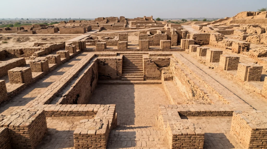
As Gregory L. Possehl detailed in The Indus Civilization: A Contemporary Perspective (2002), Mohenjo-daro alone possessed roughly 700 cylindrical brick-lined public and private wells sunk deep into the alluvial water table. Wastewater from upstairs bathrooms flowed down terracotta vertical pipes set into the house walls and emptied through settling sumps into covered brick drains running along every street, fitted with removable stone inspection slabs for municipal cleaning crews. On the western Citadel mound stands the Great Bath, a sunken brick tank measuring roughly 12 by 7 metres and 2.4 metres deep, reached by twin staircases and rendered watertight through finely fitted gypsum mortar and a 2.5-centimetre layer of natural bitumen tar — almost certainly used for collective ritual purification rather than secular swimming.
Harappa, Dholavira and civic water engineering
While Mohenjo-daro relied on the high water table of the lower Indus floodplain, other Harappan metropolises adapted their hydraulic engineering to dramatically different ecological zones. At Harappa in the Ravi River basin of Punjab — excavated by Madho Sarup Vats in the 1920s and 1930s and since 1986 by the Harappa Archaeological Research Project (HARP) directed by Richard H. Meadow and Jonathan Mark Kenoyer — the city grew into a cluster of walled mounds (Mounds AB, E, ET, and F) surrounded by massive mud-brick perimeter walls that controlled market access rather than repelling siege engines. Large multi-roomed brick foundations on Mound F and at Mohenjo-daro, labelled “Granaries” by early British excavators like Mortimer Wheeler, are now interpreted by Kenoyer as monumental public halls or administrative warehouses lacking any charred grain deposits.
Even more ambitious water conservation appeared at Dholavira, a 100-hectare stone-built city on Khadir Bet island in the arid Rann of Kutch in Gujarat, excavated between 1990 and 2005 by ASI director R. S. Bisht. Because Dholavira received less than 260 millimetres of erratic annual rainfall and had no perennial river, Harappan engineers constructed check-dams across two seasonal storm-water streams (the Manhar and Mansar) and diverted the runoff into at least sixteen monumental rock-cut and stone-lined reservoirs surrounding the Citadel, Middle Town, and Lower Town. Together, these interconnected step-reservoirs occupied nearly a fifth of the walled city’s footprint and stored over 250,000 cubic metres of fresh water through the dry months.
Trade, standard weights and the Indus script
The economic prosperity of the Indus Valley Civilisation rested on intensive two-season agriculture paired with long-distance craft networks that linked rural resource zones in South Asia to maritime trading partners in Oman, Bahrain, and southern Mesopotamia.
Meluhha, Mesopotamian trade and standardised weights
Harappan farmers practiced double-cropping tuned to South Asia’s bimodal rainfall regime: winter rabi crops of wheat, barley, peas, lentils, and chickpeas watered by winter rains and river floods, followed by summer kharif crops of millets, sesame, and cotton fed by the summer monsoon. Excavations at Mehrgarh and Mohenjo-daro preserve the earliest known spun and woven Gossypium arboreum cotton threads in the Old World (found preserved by corrosion salts around a silver vase at Mohenjo-daro). Alongside farming, specialized urban workshops transformed raw materials imported from across the subcontinent: banded chert blades from the Rohri Hills in Sindh, copper ore from the Khetri mines of Rajasthan and Oman, marine shell (Turbinella pyrum) from Gujarat, and red carnelian agate from Ratanpur.
From coastal ports such as Lothal on the Gulf of Khambhat — where archaeologist S. R. Rao excavated a 214-by-36-metre brick basin interpreted either as a tidal dockyard or an irrigation tank — and Sutkagen Dor on the Makran coast, Harappan reed and timber vessels sailed west across the Arabian Sea. In cuneiform tablets from the Akkadian and Ur III empires in Mesopotamia, scribes recorded ships arriving from three eastern maritime lands: Dilmun (Bahrain), Magan (Oman and the United Arab Emirates), and Meluhha — universally identified by Assyriologists and South Asian archaeologists with the Indus region. An inscription of Sargon of Akkad (c. 2334–2279 BC) boasts that ships from Meluhha, Magan, and Dilmun moored directly at the quay of his capital Agade, delivering etched carnelian beads, ivory combs, peacocks, timber, and lapis lazuli.
To regulate tax collection and commercial exchange across a territory a thousand kilometres wide, Harappan cities enforced a single, remarkably precise system of cubical stone weights carved from polished chert. As Jonathan Mark Kenoyer documented in Ancient Cities of the Indus Valley Civilization (1998), the lower weights followed a binary progression (1, 2, 4, 8, 16, 32, and 64, where the base unit of 16 ratios weighed approximately 13.65 to 13.7 grams), while higher denominations scaled decimally (160, 200, 320, 640, 1,600), found alongside bronze balance pans in market gateways and bead-makers’ workshops.
Crafts, steatite seals and the Indus script
The technical signature of Harappan artisans was high-temperature pyrotechnology and micro-craftsmanship rather than giant royal statuary. In bead workshops at Chanhudaro and Lothal, lapidaries heated yellow-brown chalcedony nodules in kilns to produce deep red carnelian, drilled slender beads up to ten centimetres long using specialized hardened greenstone (ernestite) drill bits, and bleached geometric white patterns onto the stone with alkaline plant ash (“etched carnelian beads” found in the Royal Cemetery at Ur in Iraq and preserved in the British Museum).
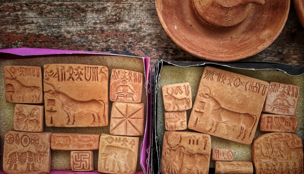
Most famous of all Harappan artefacts are the thousands of square stamp seals carved in intaglio from soft steatite (soapstone), coated with an alkali glaze, and baked in a kiln at over 1,000 degrees Celsius until they turned hard and lustrous white. Carrying a perforated boss on the back so a merchant or official could wear the seal on a cord and press it into wet clay tags (bullae) sealing bales of trade goods, the seals typically depict a single animal — most commonly the one-horned “unicorn” bovid, alongside humped zebu bulls, Indian rhinoceroses, elephants, water buffalo, and tigers — standing beneath a single line of the Indus script.
As Asko Parpola catalogued across the multi-volume Corpus of Indus Seals and Inscriptions (1987–2010), the Indus script appears on roughly 4,000 to 5,000 surviving objects, including steatite seals, copper tablets, miniature stoneware bangles, and pottery sherds. Written predominantly from right to left (confirmed by sign crowding at the left edge and overlapping strokes on pottery), the script employs approximately 400 to 450 distinct principal signs. Alongside the animal seals, religious or mythological scenes appear on icons such as the famous “Pashupati” seal (Mackay Seal 420 from Mohenjo-daro), which shows a horned figure seated in a yogic posture surrounded by an elephant, tiger, rhinoceros, and water buffalo, and on terracotta female figurines that suggest household fertility cults and reverence for the sacred pipal tree (Ficus religiosa).
Indus Valley Civilisation decline and cultural legacy
The Indus Valley Civilisation decline after 1900 BC was not a sudden military slaughter by invading armies, but a protracted, multi-century process of climatic aridification, river reorganization, and urban decentralisation that shifted South Asia’s population centre eastward toward the upper Ganges and Gujarat.
How climate research overturned the invasion myth
For decades after the 1940s, popular textbooks attributed the collapse of Mohenjo-daro and Harappa to a violent conquest by horse-riding Indo-Aryan invaders from Central Asia. In his 1947 Harappa report, British archaeologist Sir Mortimer Wheeler famously pointed to thirty-seven unburied skeletons found in the upper street levels of Mohenjo-daro and Dramatically declared that the Vedic war-god “Indra stands accused” of destroying the Harappan pur (fortified cities).
Modern bioarchaeological and stratigraphic forensics completely demolished Wheeler’s massacre hypothesis. In a landmark osteological reanalysis published by Kenneth A. R. Kennedy (God-Apes and Fossil Men, 2000) and George F. Dales (1964), anthropologists proved that the Mohenjo-daro skeletons did not belong to a single chronological layer, showed no unhealed bronze weapon cuts from a battle, and occurred long after the Citadel had already been abandoned. At Harappa, CEMETERY H skeletons likewise showed biological continuity and elevated rates of infectious disease (including leprosy and tuberculosis, documented by Gwen Robbins Schug in 2013) rather than military trauma.
Instead, high-resolution palaeoclimatic reconstructions published in Proceedings of the National Academy of Sciences by Liviu Giosan and colleagues (2012) and Yama Dixit, David Hodell, and Cameron Petrie (2014) point to a prolonged environmental transformation linked to the “4.2 kiloyear BP climate event” — the same late-third-millennium BC aridification phase associated with the Late Bronze Age and Old Kingdom collapses in the Near East. Oxygen-isotope records from lake sediments at Kotla Dahar in Haryana and marine cores from the Arabian Sea show that around 2100–1900 BC, the Indian Summer Monsoon weakened significantly for nearly two centuries. As monsoon-fed tributaries dried up, the perennial Ghaggar-Hakra river system — along which hundreds of dense Harappan settlements clustered in Cholistan and Haryana — dwindled into a seasonal stream, while Indus floods became too erratic to sustain huge urban grain surpluses.
De-urbanisation, eastward migration and enduring legacy
Faced with unreliable floods, soil salinisation, and declining urban sanitation, residents gradually abandoned the great metropolitan centres between 1900 BC and 1700 BC. During this Late Harappan or Localisation phase (represented by the Cemetery H culture in Punjab, the Jhukar phase in Sindh, and the Rangpur phase in Gujarat), the overarching civic apparatus dissolved: scribes stopped carving the Indus script on steatite seals, artisans stopped cutting uniform cubical chert weights, and long-distance maritime trade with Mesopotamia ceased around 1800 BC.
Yet the population did not vanish. Archaeological surveys show a massive demographic shift from the drying Ghaggar-Hakra and lower Indus basins eastward into the wetter Himalayan foothills of eastern Punjab, Haryana, and western Uttar Pradesh, as well as southward into Saurashtra, where thousands of smaller rural villages thrived by cultivating drought-resistant summer millets (jowar and bajra) and rice. As Jonathan Mark Kenoyer and Jane McIntosh emphasise, Harappan material and cultural practices left a deep imprint on later Indian civilisation, visible when urban life re-emerged in the Ganges Valley leading up to the Maurya Empire and the edicts of Ashoka. The traditional South Asian binary-decimal weight ratios (used for ratti and tola jewelers’ weights into the nineteenth century), the manufacture of shell and glass bangles as markers of female status, the lost-wax bronze casting technique exemplified by Mohenjo-daro’s “Dancing Girl”, the reverence for the pipal tree and humped bull, and courtyard house architecture all trace directly back to the third-millennium BC Indus cities.
Palaceless rule, undeciphered seals and Rakhigarhi DNA
Three major scientific puzzles make the Indus Valley Civilisation unique among the primary cradles of urban antiquity: how five vast metropolises enforced uniform building and weight codes across a million square kilometres without detectable kings, why computer scientists and linguists remain deadlocked over its writing system, and what the first ancient-DNA genome from a Harappan burial revealed in 2019.
How a million-square-kilometre realm worked without kings or palaces
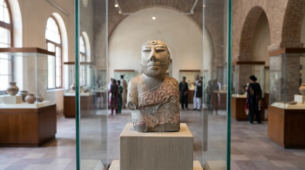
In third-millennium BC Egypt and Mesopotamia, state power is unmistakable in the archaeological record: pharaohs and lugals built colossal stone pyramids and ziggurats, carved boasts of military slaughter on stelae, stockpiled bronze weaponry, and buried their dynasties in lavish tombs like the Royal Cemetery at Ur. By contrast, after a century of excavating Harappa, Mohenjo-daro, Rakhigarhi, and Dholavira, archaeologists have found not a single unambiguous royal palace, monumental temple, dynastic king-list, battlefield relief, or elite tomb packed with gold bullion. Even the famous 17.5-centimetre steatite “Priest-King” bust from Mohenjo-daro — named by John Marshall — is small enough to hold in one hand and represents an idealized clan elder or ritual specialist rather than a named conqueror.
How, then, did Harappan cities enforce standardized 1:2:4 brick sizes, maintain city-wide sewage grids, and regulate chert weights across a territory twice the size of France? Archaeologists remain divided between two principal models. Gregory L. Possehl argued that the Harappan world functioned as a “corporate” or “heterarchical” society without a single state apparatus, governed instead by civic councils that rejected royal self-aggrandisement in favour of shared ideological norms and water-management rituals. Jonathan Mark Kenoyer proposes a more competitive oligarchic model: rather than a single hereditary monarch, each major city-state was ruled by coalitions of competing merchant guilds, landowners, and ritual specialists based on the separate walled mounds found at Harappa and Dholavira. In Kenoyer’s view, these elites legitimised their authority not through standing armies or war monuments, but through control of long-distance trade networks and public displays of costly ornaments — such as micro-drilled carnelian belts and stoneware bangles carrying seal inscriptions — while keeping their burials remarkably modest.
Why the Indus script defies decipherment
The absence of monumental royal propaganda also explains why the Indus script has resisted over a hundred published decipherment claims since the 1920s. Unlike Egyptian hieroglyphs or Mesopotamian cuneiform, no bilingual inscription (a Harappan Rosetta Stone) has ever been found in either South Asia or the Persian Gulf, and the underlying language family of the Harappan people is unknown before the decipherment begins. Worse still for cryptanalysts is the extreme brevity of the surviving corpus: across roughly 4,000 to 5,000 inscribed seals and tablets, the average inscription is just 4.6 signs long, and the single longest known inscription on a single surface contains only 26 signs (or 34 signs across three faces of a moulded terracotta tablet from Harappa), alongside a 10-sign monumental gypsum-inlaid wooden signboard discovered inside the northern gateway of the Citadel at Dholavira.
Over the past fifty years, statistical and computational studies by Finnish Indologist Asko Parpola (Deciphering the Indus Script, 1994), Russian scholar Yuri Knorozov, and Indian epigraphist Iravatham Mahadevan (1977) established that the sign count (roughly 400–450 signs) is too large for an alphabet or simple syllabary and best fits a logo-syllabic script in which signs represent whole words or syllables via the rebus principle. Parpola and Mahadevan argue that the positional grammar of the signs and the presence of a surviving Dravidian linguistic pocket (Brahui) in Balochistan point to an ancestral Proto-Dravidian language, suggesting for instance that the frequent “fish” sign (min in Dravidian languages, which means both “fish” and “star”) functioned as a homophone for astral deities found in priestly titles.
That linguistic consensus was challenged in 2004 when historian Steve Farmer, computational linguist Richard Sproat, and Sanskritist Michael Witzel published a controversial paper arguing that the Indus script did not encode spoken language at all, comparing its short, non-repeating strings to medieval European heraldic crests or Near Eastern emblem systems. In turn, computer scientists Rajesh P. N. Rao, Nisha Yadav, Mayank Vahia, and Iravatham Mahadevan published a 2009 counter-study in Science demonstrating that the conditional entropy (the statistical predictability of one sign following another) of Indus inscriptions matches natural linguistic scripts like Sumerian cuneiform and Old Tamil far more closely than non-linguistic symbol systems, leaving the linguistic versus emblem debate one of archaeology’s sharpest open questions.
What the 2019 Rakhigarhi ancient-DNA study changed
Because heat and monsoon humidity rapidly degrade DNA in South Asian soils, geneticists were unable for decades to recover endogenous ancient DNA from any Harappan skeleton to test who the Indus people were. That barrier fell in September 2019 with the simultaneous publication of two landmark peer-reviewed studies: a paper in Cell led by archaeologist Vasant Shinde, geneticist Niraj Rai, Vagheesh Narasimhan, and David Reich, and a companion continent-wide study of 523 ancient Eurasian genomes in Science led by Narasimhan, Nick Patterson, and Reich.
After screening more than sixty skeletal samples from the cemetery at Rakhigarhi in Haryana — the largest documented Harappan metropolis, spanning over 300 hectares — the team succeeded in extracting a low-coverage whole genome from the dense petrous bone of individual I6113, a woman buried among standard Harappan ceramic vessels between 2800 and 2300 BC. Her genetic profile closely matched eleven contemporaneous individuals excavated at the eastern Iranian and Turanian sites of Gonur Depe (Bactria-Margiana Archaeological Complex) and Shahr-i-Sokhta, whom archaeologists and geneticists identified as Harappan migrants or trade diaspora populations living abroad.
The Rakhigarhi genome settled two foundational questions while opening new ones. First, individual I6113 combined deep ancestral lineages related to ancient Iranian hunter-gatherers/herders (who split from Zagros mountain farmers over 10,000 years ago, before the invention of farming in Iran) and indigenous South Asian hunter-gatherers (Ancient Ancestral South Indians, AASI), demonstrating that farming in South Asia was not simply brought intact by Neolithic migrants from the Fertile Crescent. Second, the Rakhigarhi woman carried zero detectable Steppe pastoralist ancestry (Western Steppe Herders / Yamnaya-related ancestry), which according to Narasimhan et al. (2019) only begins appearing in northern South Asian genetic profiles in the second millennium BC after the decline of the Indus cities. At the same time, the Rakhigarhi genome forms the single largest ancestral component of the vast majority of modern populations living across both northern and southern South Asia today, proving profound biological continuity between the builders of the Bronze Age Indus cities and contemporary South Asians.
Surveying the Indus Valley Civilisation across its full two-thousand-year arc — from the mud-brick villages of Mehrgarh and the bitumen-sealed Great Bath of Mohenjo-daro to the rock-cut reservoirs of Dholavira and the eastward dispersal after 1900 BC — challenges traditional textbook definitions of how complex states must work. For seven centuries during the Mature Harappan era, millions of urban and rural residents maintained uniform weights, hygienic street drainage, and intercontinental maritime commerce with Mesopotamia without erecting monuments to kings or celebrating warfare in art. Combined with the statistical resilience of the undeciphered Indus script and the genetic continuity revealed at Rakhigarhi, the Harappan world stands not as a vanished anomaly, but as the foundational urban substrate of South Asian history.
References
Primary sources
- John Marshall, ed., Mohenjo-daro and the Indus Civilization: Being an Official Account of Archaeological Excavations at Mohenjo-daro Carried Out by the Government of India between the Years 1922 and 1927, 3 vols. (London: Arthur Probsthain, 1931).
- Ernest J. H. Mackay, Further Excavations at Mohenjo-daro: Being an Official Account of Archaeological Excavations at Mohenjo-daro Carried Out by the Government of India between the Years 1927 and 1931, 2 vols. (Delhi: Manager of Publications, 1938).
- Madho Sarup Vats, Excavations at Harappa: Being an Account of Archaeological Excavations at Harappa Carried Out between the Years 1920–21 and 1933–34, 2 vols. (Delhi: Manager of Publications, 1940).
- Asko Parpola, B. M. Pande, and Petteri Koskikallio, eds., Corpus of Indus Seals and Inscriptions, 3 vols., Annales Academiae Scientiarum Fennicae, Series B, 239, 240, 359 (Helsinki: Suomalainen Tiedeakatemia, 1987–2010).
Secondary sources
- Gregory L. Possehl, The Indus Civilization: A Contemporary Perspective (Walnut Creek, CA: AltaMira Press, 2002).
- Jonathan Mark Kenoyer, Ancient Cities of the Indus Valley Civilization (Karachi and New York: Oxford University Press and American Institute of Pakistan Studies, 1998).
- Jane R. McIntosh, The Ancient Indus Valley: New Perspectives (Santa Barbara, CA: ABC-CLIO, 2008).
- Rita P. Wright, The Ancient Indus: Urbanism, Economy, and Society (Cambridge: Cambridge University Press, 2010).
- Asko Parpola, Deciphering the Indus Script (Cambridge: Cambridge University Press, 1994). Steve Farmer, Richard Sproat, and Michael Witzel, “The Collapse of the Indus-Script Thesis: The Myth of a Literate Harappan Civilization,” Electronic Journal of Vedic Studies 11, no. 2 (2004): 19–57. DOI: 10.11588/ejvs.2004.2.620.
- Rajesh P. N. Rao, Nisha Yadav, Mayank N. Vahia, Hrishikesh Joglekar, R. Adhikari, and Iravatham Mahadevan, “Entropic Evidence for Linguistic Structure in the Indus Script,” Science 324, no. 5931 (2009): 1165. DOI: 10.1126/science.1170391.
- Liviu Giosan, Peter D. Clift, Mark G. Macklin, Dorian Q. Fuller, Stefan Constantinescu, Julie A. Durcan, Thomas Stevens, Geoff A. T. Duller, Ali R. Tabrez, K. Gangal, Ronojoy Adhikari, A. Alizai, Florin Filip, Sam VanLaningham, and James P. M. Syvitski, “Fluvial Landscapes of the Harappan Civilization,” Proceedings of the National Academy of Sciences 109, no. 26 (2012): E1688–E1694. DOI: 10.1073/pnas.1112743109.
- Vasant Shinde, Vagheesh M. Narasimhan, Nadin Rohland, Mallick Swapan, Matthew Mah, Mark Lipson, Nakagome Shigeki, Rebecca Bernardos, et al., “An Ancient Harappan Genome Lacks Ancestry from Steppe Pastoralists or Iranian Farmers,” Cell 179, no. 3 (2019): 729–735.e10. DOI: 10.1016/j.cell.2019.08.048.
- Vagheesh M. Narasimhan, Nick Patterson, Priya Moorjani, Nadin Rohland, Rebecca Bernardos, Swapan Mallick, Iosif Lazaridis, et al., “The Formation of Human Populations in South and Central Asia,” Science 365, no. 6457 (2019): eaat7487. DOI: 10.1126/science.aat7487.
- Kenneth A. R. Kennedy, God-Apes and Fossil Men: Paleoanthropology of South Asia (Ann Arbor: University of Michigan Press, 2000).
Further reading (not drawn on for this article)
- Iravatham Mahadevan, The Indus Script: Texts, Concordance and Tables, Memoirs of the Archaeological Survey of India 77 (New Delhi: Archaeological Survey of India, 1977).
- Nayanjot Lahiri, Finding Forgotten Cities: How the Indus Civilization Was Discovered (New Delhi: Permanent Black, 2005).
- Shereen Ratnagar, Encounters: The Westerly Trade of the Harappa Civilization (Delhi: Oxford University Press, 1981).